Our proposals
A vibrant and sustainable community
Our aspiration for the development at Badsell Farm is to create a vibrant and sustainable community that integrates into the local area, providing additional high-quality new homes and associated infrastructure that will benefit both existing and new residents.
Key benefits
Key features
The development will deliver a number of key benefits including:
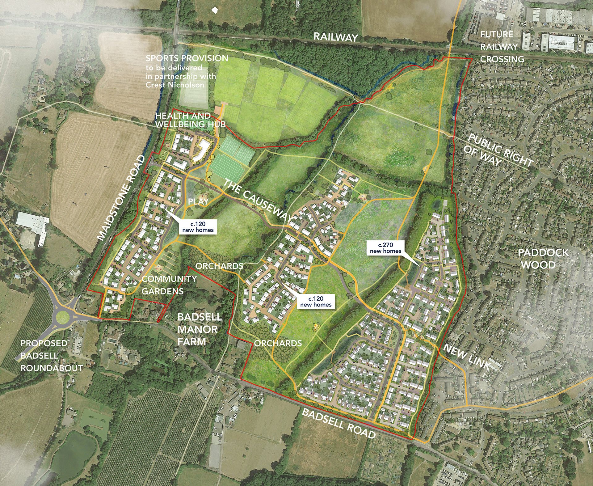
- In the region of 500 new homes – 40% of these homes will be affordable.
- A health and wellbeing hub with 0.5ha of space reserved for a healthcare facility.
- Tennis courts with parking provision as extension to sports provision north of the site.
- Nearly six times more open space than required including areas for play, wildlife and planting.
- Vehicular, pedestrian and cycle access to proposed sports provision north of the site.
- Sustainable modes of transport including a bus route to provide a new circular route through Paddock Wood and new walking and cycling links.
- A new edge to Paddock Wood in perpetuity – that integrates development with the existing landscape features
- Significant biodiversity net gain with new grassland, whiteflower meadows and native rich species with grass planting.
- Surface water flood resilience through flood betterment and sustainable drainage strategy.

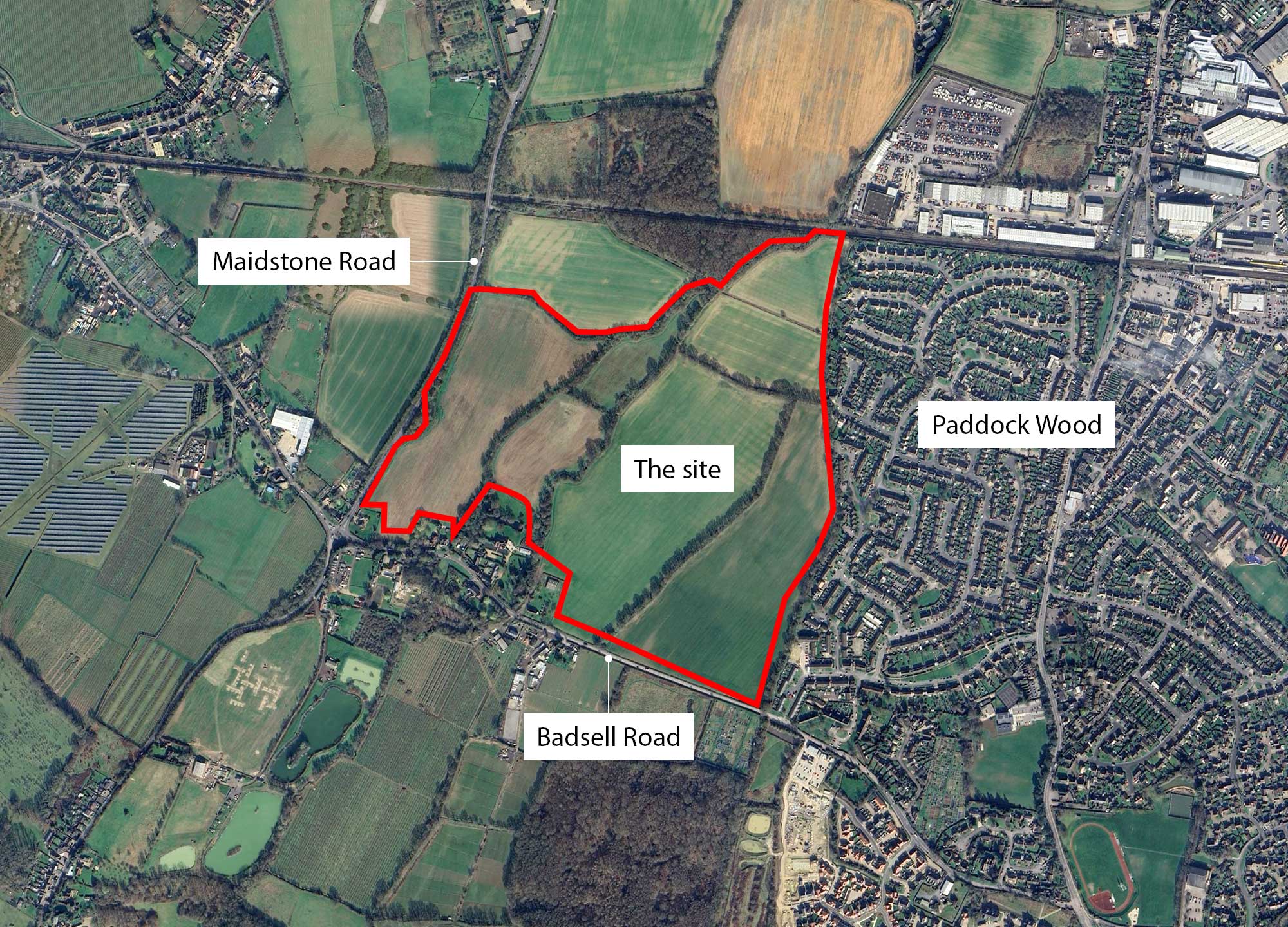
The site
Site masterplan
 Proposed active links
 Proposed primary route
 Proposed sports provision
 Proposed homes
 Proposed attenuation basins
Multifunctional landscape
Ensuring every home is close to open space
Landscaping and green open space is at the heart of the proposals, ensuring every home is in close proximity to open space to help foster community cohesion and wellbeing for all to enjoy.
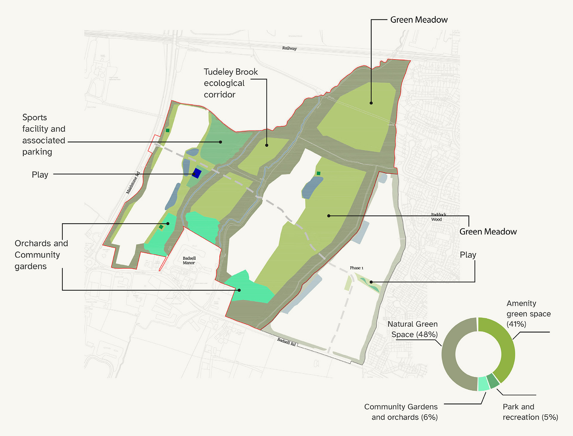
 Red line boundary
 Phase 1 boundary
 Natural green space (includes existing trees, hedges, Root Protections Areas and associated buffers)
 Amenity green space (includes footpaths and cycleways, and elements of the primary movement corridor)
 Park and recreational grounds
 Play space (children)
 Play space (youth)
 Allotments
 Attenuation
 Indicative alignment of primary movement corridor. To include swales and active corridor.
Movement and connectivity
Prioritising active travel
Two vehicular accesses into the Site will be created – one from Badsell Road and the other from Maidstone Road.
“The Causeway” will provide the principal vehicular route through the site connecting Badsell Road to Maidstone Road. It will form part of the proposed Paddock Wood circular bus route and will prioritise active travel through the use of a bus gate as the route crosses the Tudeley Brook.
Active travel
A network of pedestrian and cycle links are proposed to tie in with exiting Public Right of Way (PRoW) and to enable better connections into and from Paddock Wood and Five Oak Green. This includes:
- A new pedestrian and cycle link north of Badsell Road.
- A new link to the east connecting on to Fuggles Close.
- A north-south link will connect the site to the existing PRoW and further to the future railway crossing.
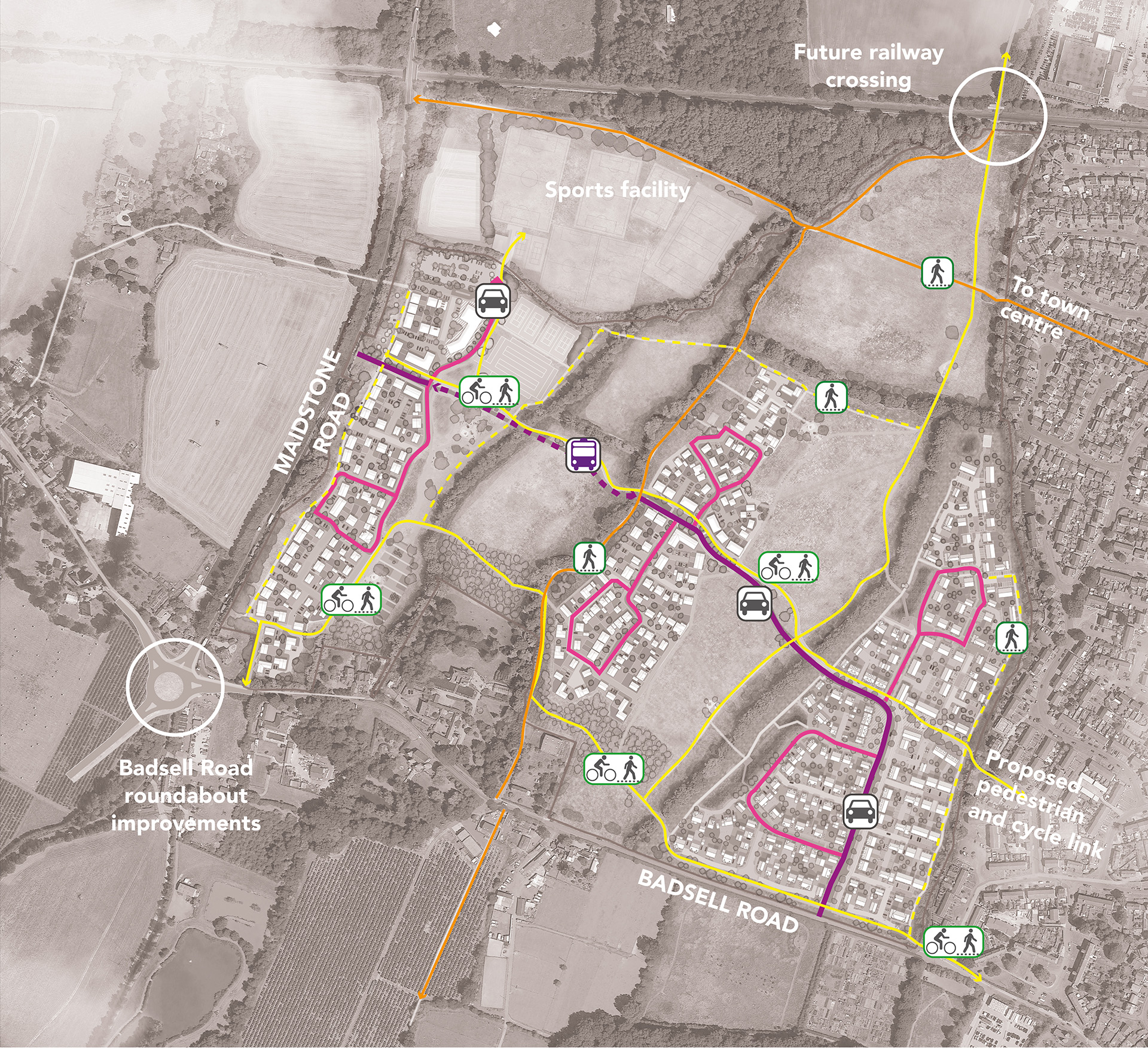
 Public Right of Way
 Proposed primary active routes
 Proposed secondary active routes
 Primary vehicular route
 Bus only
 Secondary vehicular route
Health and wellbeing
A shared sports vision
The Structure Plan for the strategic growth around Paddock Wood including land in East Capel identified a new sports hub on land to the north of this parcel together with land being promoted by Crest Nicholson to the north.
The sports provision is yet to be determined and will be delivered through further working with stakeholders.
In accordance with the above, the site will provide car parking spaces for the sport facility and cycle and pedestrian access to the proposed sports pitches, clubhouse and changing facility in the north-western parcel located north of the site.
Health and Wellbeing Hub
A new Health and Wellbeing Hub (c.700 sqm) is proposed alongside the Sports Provision to
provide a health care facility in line with the Emerging Local Plan. Co-located with the sports provision, this area of the masterplan is envisaged to provide healthcare in the form of a doctor’s surgery or ancillary unit of Pembury Hospital subject to discussion with the NHS. There is potential for a small cafe or similar within or adjacent to the Hub.
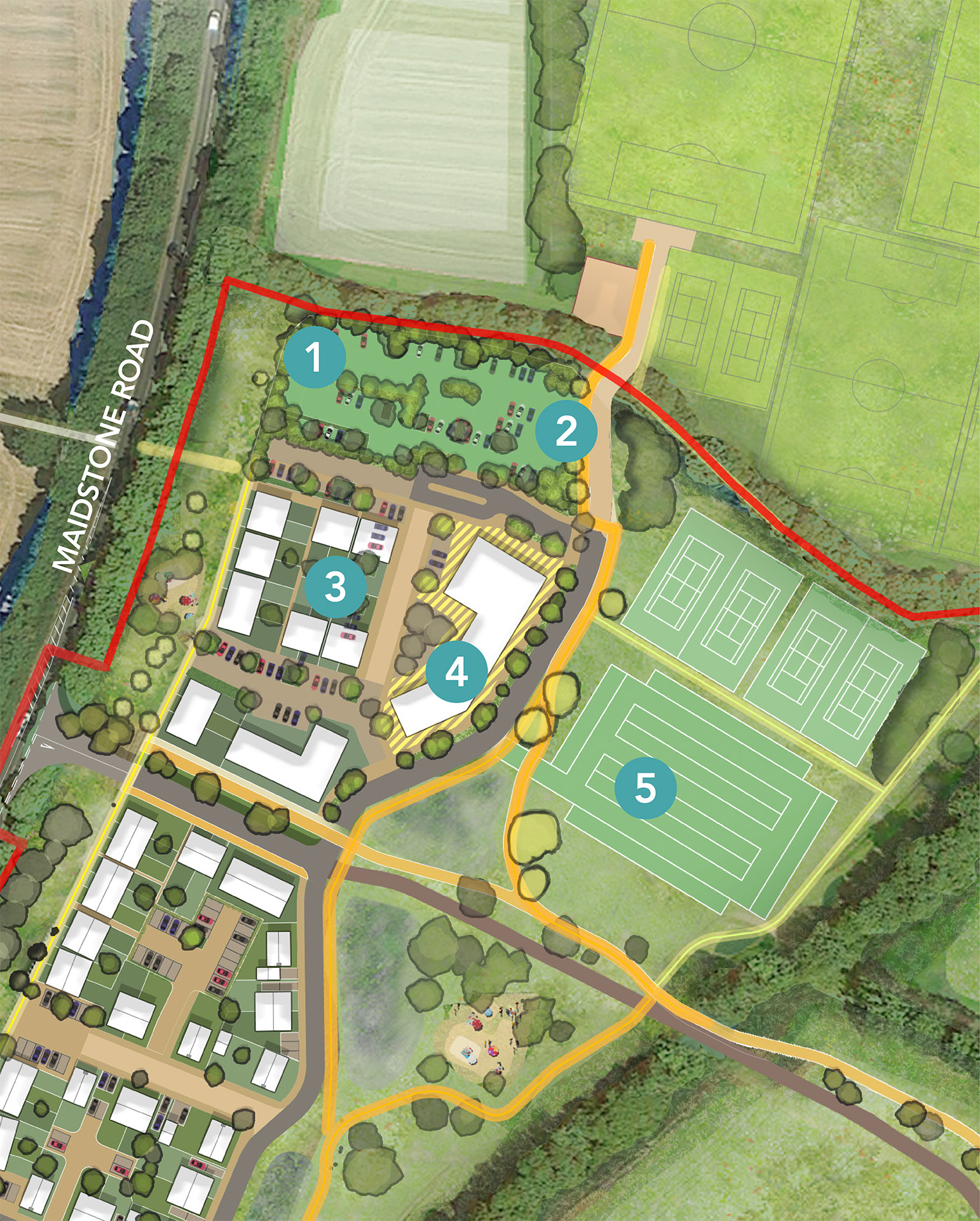
- 1Parking associated with future healthcare provision
- 2Access to sports provision in the north of the site
- 3Grouping of homes
- 4Indicative location of future healthcare facility
- 5Proposed parking for sports provision
Sustainable drainage
Effective management of surface water
The proposals have been designed to effectively manage surface water. The system is robustly designed to manage severe weather that happens very rarely, such as a 1-in-100-year storm event and to account for climate change.
The proposals integrate a comprehensive flood mitigation strategy by combining natural landscape features with engineered solutions. This is being developed in close conjunction with Kent County Council as Lead Local Flood Authority and the Upper Medway Drainage Board.
Key measures include:
- Sustainable Urban Drainage Systems (SuDS) and attenuation basins to capture, control and release water generated on-site back to pre-development rates.
- Use of clear-span bridges across Tudeley Brook and drainage ditches to avoid culverting and reduce flood risk.
- Naturalised water meadows and wetlands to slow, store, and filter water flow.
- Enhanced green infrastructure to support biodiversity while improving resilience to surface water flooding.
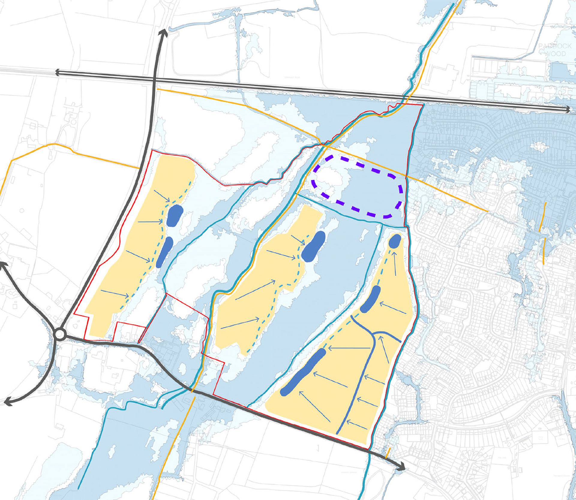
 Existing watercourses
 Proposed surface water flow
 Proposed attenuation basins
 Proposed swales
 Indicative area being considered for flood alleviation
 Flood zone 2
 Flood zone 3
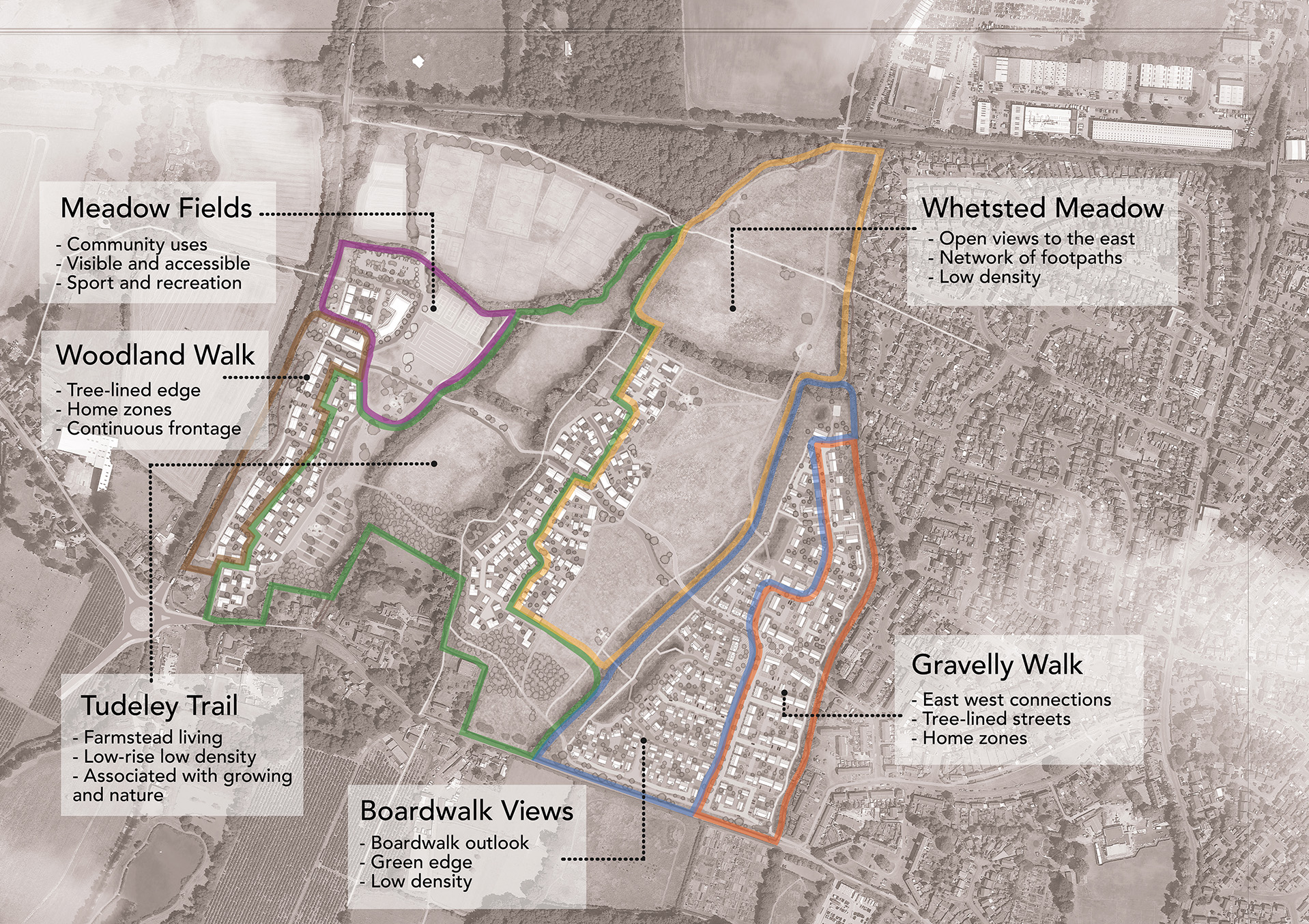
Living in the landscape
Character that reflects the wider landscape
The character of proposed homes reflect their immediate and wider landscape setting and are underpinned by the following objectives:
- Active and healthy living
- Growing produce and community cohesion
- Embracing nature